Tag Archives: History of Lenox

The Establishment of Berkshire County

Berkshire County was established in 1761 — almost a hundred years after Hamshire (later Hamden, Hampshire and Franklin) County to the East.  Why establish a new Massachusetts county at all?  Why so much later than the rest of the state?

Objectives of Settlement Included Defense ad Revenue

By 1761, the last of the French and Indian wars were winding down, but the English administration had no way of knowing they were going to end up controlling the northeast of what would become the United States.  So, settlement created an obstacle for potential continued raids by the French and their Indian allies.  It also led to road building and increased trade  On the flip side, the winding down of potential raids with the English capture of Quebec September 13, 1759, made settlement along the Hudson and the Housatonic more attractive.

untitled-1
At the time the county was founded, “official” towns were limited to upper and lower Housatonic, and Poontusuck. Although Poontusuck had been temporarily abandoned drinking the French and Indian War.

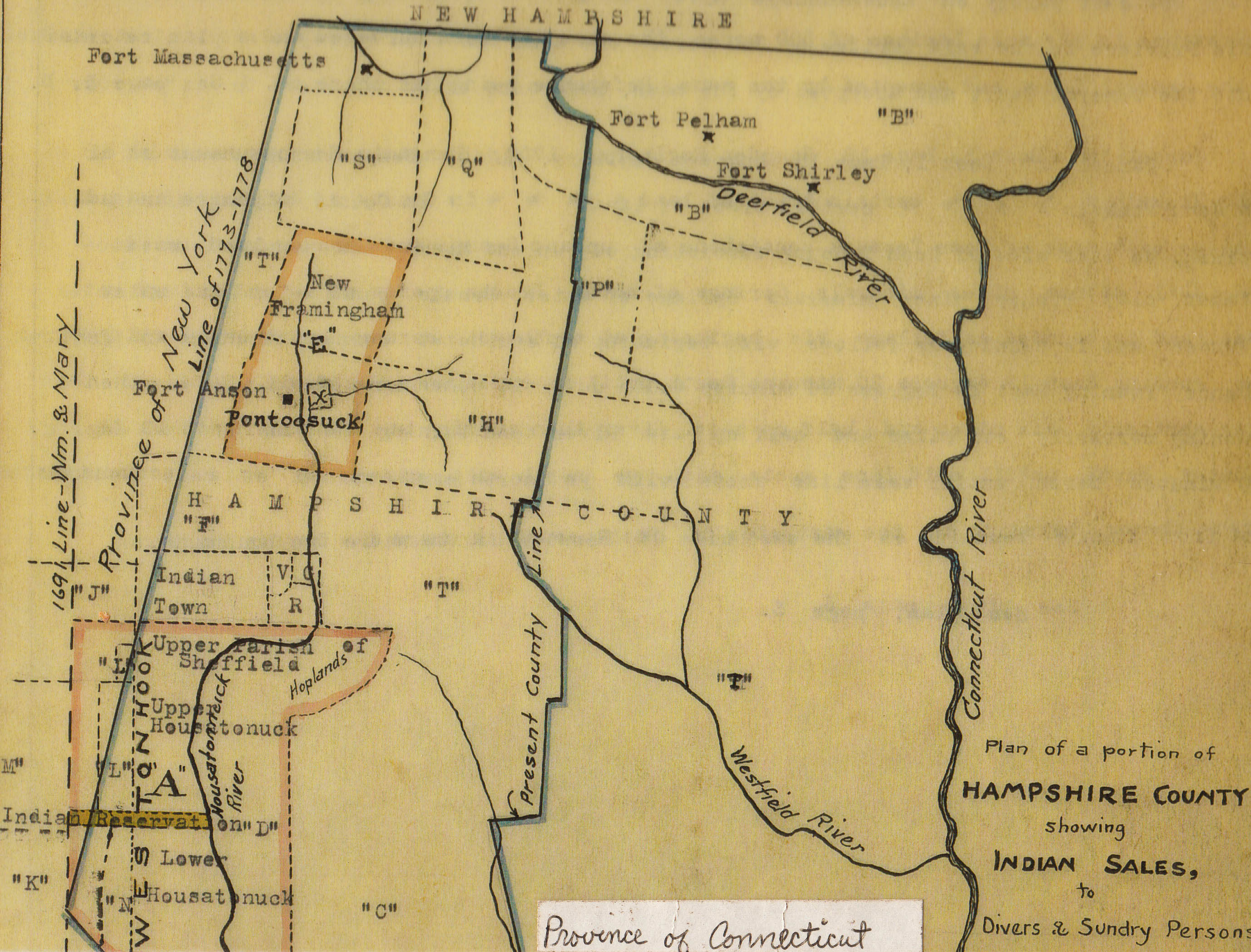
As we discussed in the history of Sheffield,  New York landholders claimed southwestern Massachusetts based on purchases 1685-1704 from the Indians called the Westenhook patent.  At one time, New York claimed their boundary ran to the Connecticut River.  As indicated by the map below, there was still, as of 1761,  controversy about the border remained.

Early Berkshire County Potential Townships

Settlement, the royal Massachusetts government reasoned, would help establish the border.  In fact, the Massachusetts-New York border was not finally settled until a 1787 survey done by David Rittenhouse and Thomas Hutchins.

Many of the grants made prior to the formation of Berkshire County were in what would become Lenox.

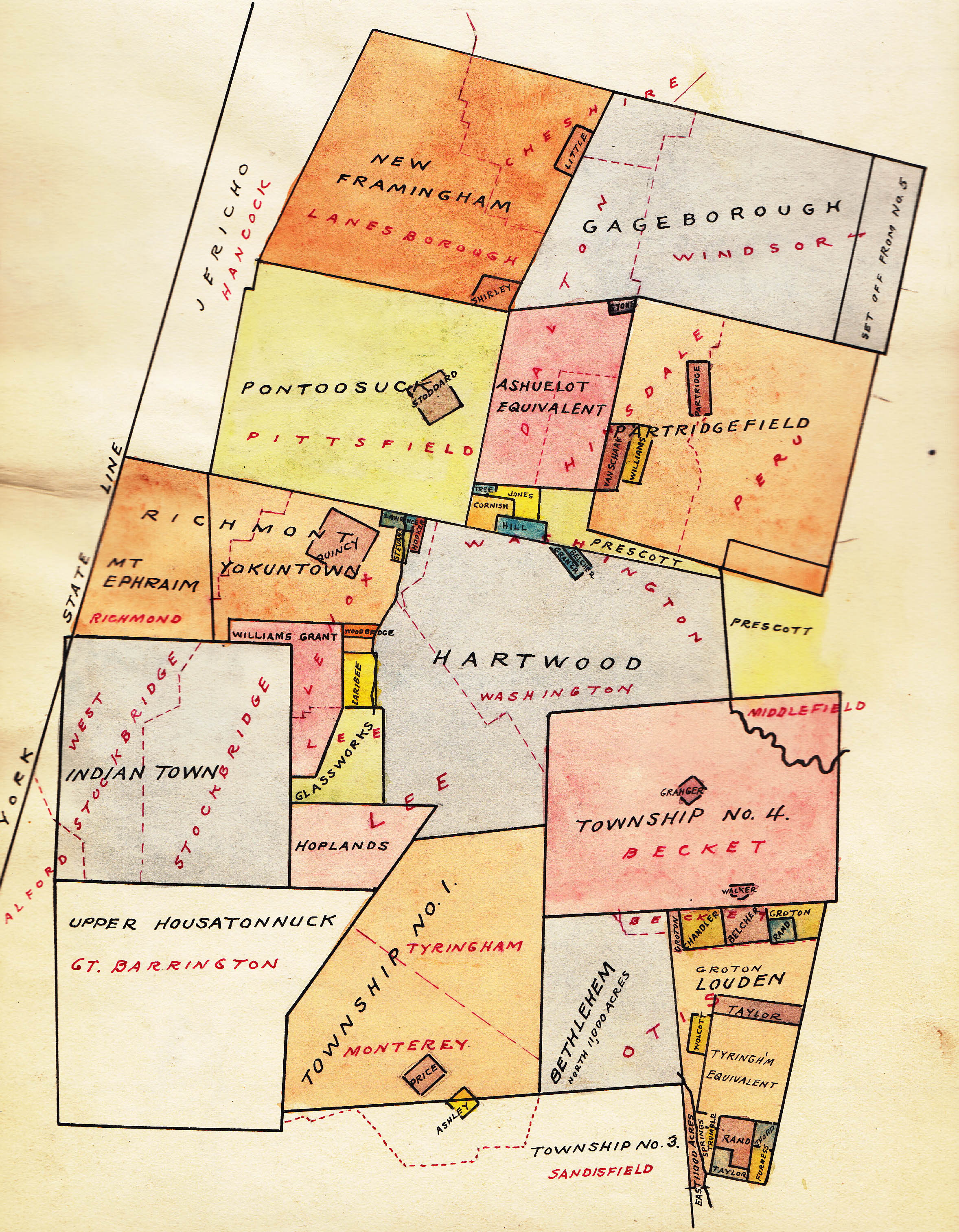
Detail of the early county map shows the land grants that had been given out prior to the establishment of Berkshire County.  Many of them fell into what would become Lenox.

Finally, settlement meant revenue for the commonwealth from land sales and income from settlers.  The Stamp Act was coming and the English were scrambling to pay for the French and Indian War.

The Wild West

Because of the fear of raids, the border disputes–and of course– the mountains Berkshire County remained largely unsettled. What would become Lenox had only a handful of families at the time.  In Beer’s History of Berkshire County (page 66)* a 1744 Berkshire County population of 500 is estimated.  We have not yet found a source for an estimate as of 1761 but 1,000 would be a reasonable guess based on the 1744 population. As shown below, settlement was still limited primarily to Sheffield and Stockbridge.  Poontoosuc (later Pittsfield) had been settled then temporarily abandoned during the last French and Indian War.

The other demarcations show grants made to individuals.  Many of them would be incorporated into what would later become Lenox.

Trails had only begun to be improved to be anything like roads.  Anything that wasn’t swamp or rock was dense original growth forest with only a few meadows along the rivers.*  The hearty initial settlers would have to have been good with an ax if they intended to farm.

The Governor Makes it Official

gov bernard_191
Sir Francis Bernard (1712-1777

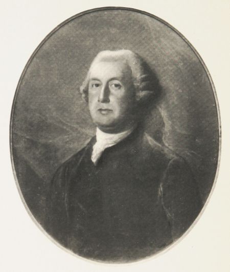
Francis Bernard (Sir Francis Bernard, the title granted after his return to England) was the royal governor of Massachusetts from 1760-1768.

He had an interesting history including being awarded Mount Dessert Island (Maine was then part of Massachusetts at the time) for his service.  HIs service was an illustration of the close circle of patronage of Colonial posts in North America.  His neighbor in England, Thomas Pownall had been an earlier governor of Massachusetts and his wife was a cousin of Lord Barrington who became Privy Councilor in 1755.  Sir Francis had been governor of New Jersey 1758-1760.

The merit of his appointment can be questioned in retrospect.  His strict and harsh enforcement of the Navigation Acts, the Sugar Act and other revenue acts contributed to the Revolution.  He sought to have British troops stationed in Boston and was finally recalled in 1769 after publication of letters in which he criticized the Colonies.

One can imagine him being petitioned by the General Assembly and whatever the lobbyists of the time were to encourage settlement of the western part of the state.  Landowners and speculators, among others, would have been interested in improving the value of their holdings.

Berkshire County UKVirginiaWater_AerialView
Berkshire County, UK; Great Windsor Park

He named the new county for the county of his birth in England.  In 1974 the town of his birth,  Brightwell-cum- Sotwell became part of Oxfordshire.  In southeastern England, Berkshire is one of the oldest counties in England (thought to date from the 840’s) and is the home of Windsor Castle.


*History of Berkshire County, Massachusetts, with Biographical Sketches of its Prominent Men, Vol. I,  edited by Mr. J.E.A. Smith, J.B. Beers & Co. New York, 1885


Settlement of Great Barrington

Modern Main Street Great Barrington

Settlement Expands to Upper Housatonic Township – Great Barrington

Voted the “Best Small Town in America,”* by Smithsonian Magazine in 2012, Great Barrington has clearly overcome early bumps in the road. However, in its early formation and settlement, Great Barrington illustrated the challenges in the systematic process  of town formation the Puritans and then the Massachusetts Royal Government had practiced for more than 100 years. Like all systems, the town formation approach required good and consistent leadership, and some luck.  It is also possible that by the mid 18th century the old ways were loosening up.

The Great Wigwam and the Patent of Wesbenhook

Unlike Lenox (for which we find no record of activity before the first settler in 1751), Great Barrington was active well before European settlement.

There is record of a “Great Wigwam” Indian settlement (thought to be near the current site of the Congregational Church)at a ford over the Housatonic but most of the Indians were gone by 1694 – said to have fled west in 1676 as a result of King Phillip’s War.

As with Sheffield and much of the rest of Berkshire County, the area had been part of a parcel (called the Patent of Westenhook which included modern day Sheffield, Great Barrington, Stockbridge, West Stockbridge, Mount Washington, Egremont and Alfrod) claimed by major landholders in New York (1685) and was open to Dutch settlers in 1705*.*  However, there was very little settlement.

It was was also on the trail (road would be an overstatement) that went from Springfield to Westfield to Kinderhook to Albany and was used by soldiers from King Phillip’s War (1676) on.

In 1722 the General Court granted the opportunity to settle lower and Upper Housatonic townships. and in 1724 property was purchased from the Mahicans.  The request made in 1733 to incorporate much of the lower parcel as Sheffield in 1733 was accepted in 1741.

Town Status and Settlement Delayed by New York Claims, Stockbridge Mission

The conflicting property claims (New York – Wesbenhook Patent vs. Massachusetts purchase from Chief Konkapot) came to a head about 1726-27.  At least one Massachusetts settler was arrested for trespassing and transported to Albany and further land sale and settlement was stalled.

Then, in 1733, the General Court passed an order appointing John Ashley, Ebeneezer Pomeroy, Esq.’s, and Mr. Thomas Ingersoll to”bring forward” settlement of the Upper Township within two years. As late as 1742, Ephraim Williams was still bringing complaints about New Yorkers surveying properties in the Upper Housatonic.

In 1736 the portion of the upper township above Monument Mountain was set aside for the Stockbridge Indian Mission and further property distribution was again halted.

One author described the Upper Township remaining as “wild as ever, a plague to the decent people in the northern part of Sheffield.”** Perhaps some of this “wildness” could be attributed to stop/start nature of the town’s status – the challenges from the Dutch claims in 1727, partition to Stockbridge in 1736, complaints about how land was being distributed and dismissal of David Ingersoll as clerk in 1749 (and annulment of all prior land distributions) – or perhaps just loosening of standards from an earlier time.

By 1742 this “plague to decent people” had 200 residents and won the right to be the North Parish of Sheffield and obtain their own minister.  They succeeded in attracting young Rev. Samuel Hopkins in 1743. However, due to delays in organizing the parish, he was not installed until 1745.

Town Status Finally Achieved in 1761- the County Seat Until After the Revolutionary War.

A further impediment to settlement, which the future Great Barrington shared with the rest of the future Berkshire County, was the French and Indian Wars  Citizens were enlisted for the 1746-1747 march on Canada under Capt. Williams.  Alarms and militia enlistment continued from 1753 to 1760.  General Amherst marched through the town in 1758 on his way to attack Ticonderoga.

Finally, in 1761 the General Court allowed the North Parish to become the town of Great Barrington. Great Barrington was the site of the County Courts in 1774 and was a scene of early defiance of the Royal government.  The town would go on to play an important role in the Revolution as well as in the aftermath – Shay’s Rebellion.

—————————-

*”The 20 Best Small Towns in America of 2012,” by Susan Spano and Aviva Shen,  Smithsonian Magazine, May 1, 2012

**History of Great Barrington, Charles James Taylor, Clark W. Bryan Publ., 1882

***Housatonic, Puritan River, by Chard Powers Smith, Rinehart and Company, 1946, p. 59

Also see:  A History of the County of Berkshire, Massachusetts, David Dudley Field, Printed by Samuel Bush, Pittsfield, 1829 “Great Barrington.”,  History of Great Barrington,