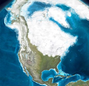
Throughout the millennia, the earth has gone through long periods of warming and cooling. The entire Pleistocene Epoch – beginning about 2MM years ago was marked by invasions of massive glaciers interrupted by warming periods. Dating of the most recent glacial advance varies but is usually described as reaching its farthest extent 20-30,000 years ago. New York and New England were, by about that time, covered by grey glaciers that were up to 10,000 feet deep.
Leveled Peaks and Created Lakes
In its retreat (beginning about 18,000 years ago) it left imprints in any softer surface. Some of these filled with melting ice including what was a large lake (from 1-12 miles wide) in the middle of the state until 2-3,000 years ago. Many of our ponds and lakes are the residual of these depressions filled with water. On a grander scale, the retreating glaciers carved out north/south valleys and ridges which finalized the layout of our hills today. [i]
What would have been left behind as the Earth warmed on Berkshire county would be marshy tundra for thousands of years.
Land Bridge
It sucked up enough moisture to lower sea levels by as much as 300 feet and wiped out any plant and animal life that had existed before.
Meanwhile, as a result of the lowered sea levels, paleo man is thought to have crossed what is now the Bering Straits from Asia to North America about 15,000 years ago and to have fanned out across the continent as the ice retreated. The earliest remains found in Massachusetts are dated at about 9,000 years ago.[i]
[i] Maps of Early Massachusetts, by Lincoln Dexter, New England Blue Print Company, 1979 – pgs 5-12
